Mission Plan:
Primary Mission : Cumulus outflow (with possible overflight of Discoverer) Alternate Mission: Clear air closure Future Mission(s):Aircraft Operations
Take-off Time: Flight #17: 1000 LDT, 28 Nov (2300 UTC, 27 Nov) Pre-flight Weather Briefing Time: Flight #17: 0800 LDT, 28 Nov (2100 UTC, 27 Nov) Updates: none Airborne Mission Scientist: Flight #17: Clarke Mission Scientist: Flight #17: HuebertShip Operations
Discoverer: Discoverer located at 42S, 142E this evening. ISS soundings continue every 6 hours. Ship will move toward Cape Grim and be located at 40 47', 144 13' by Tuesday morning. An "air drop" and pick-up will be attempted by helicopter tomorrow morning to get a smart balloon transmitter and deliver chemicals and other vital supplies. See catalog reference below for detailed instrument status. Discoverer Lead Scientist: Tim Bates Southern Surveyor: Southern Surveyor position at 0500 UTC 27/11 is approaching station P5 53S 145.5E. They will reamin sampling there for 30 hours. They have completed all required measurements to this point. Soundings are being taken every 12 hours. See catalog reference below for detailed instrument status. Southern Surveyor Lead Scientist: Bronte Tilbrook
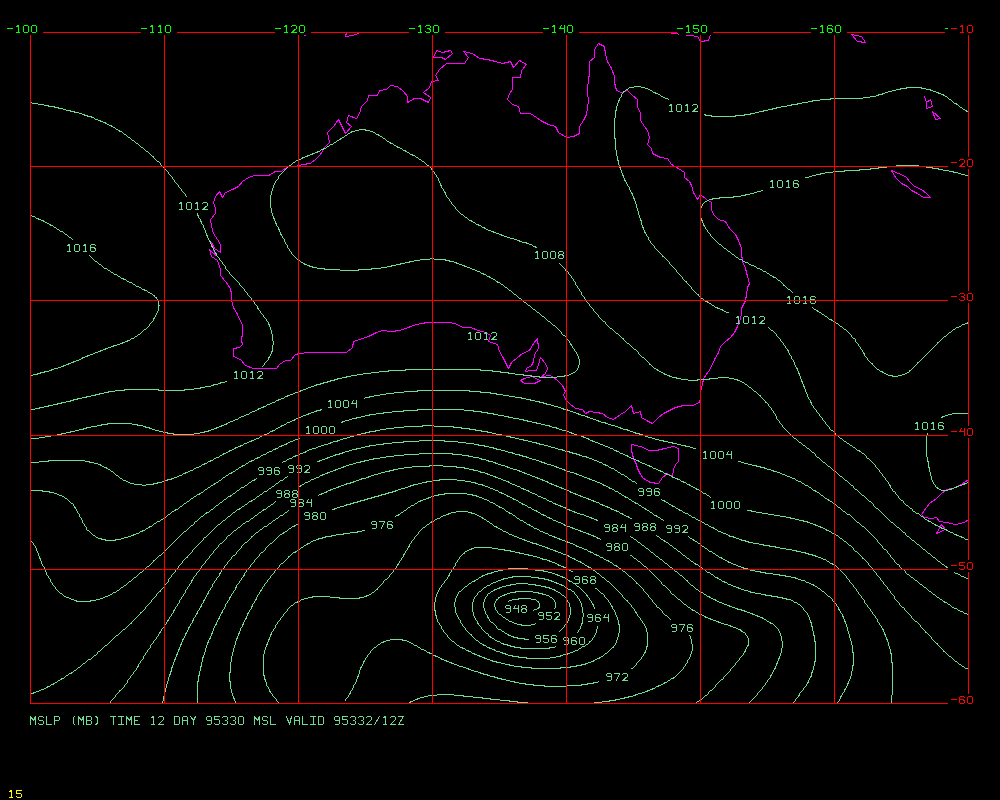
48 hour MSL P Prognosis is here
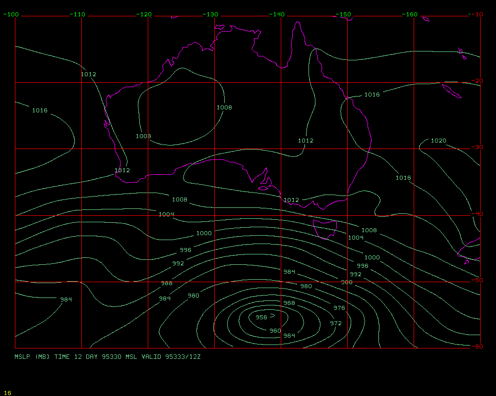
72 hour MSL P Prognosis is here
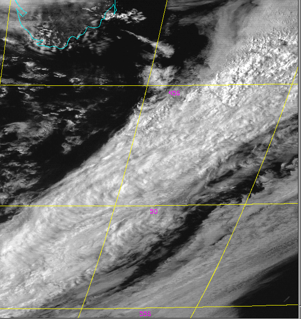
Latest Visible Sat Picture is here
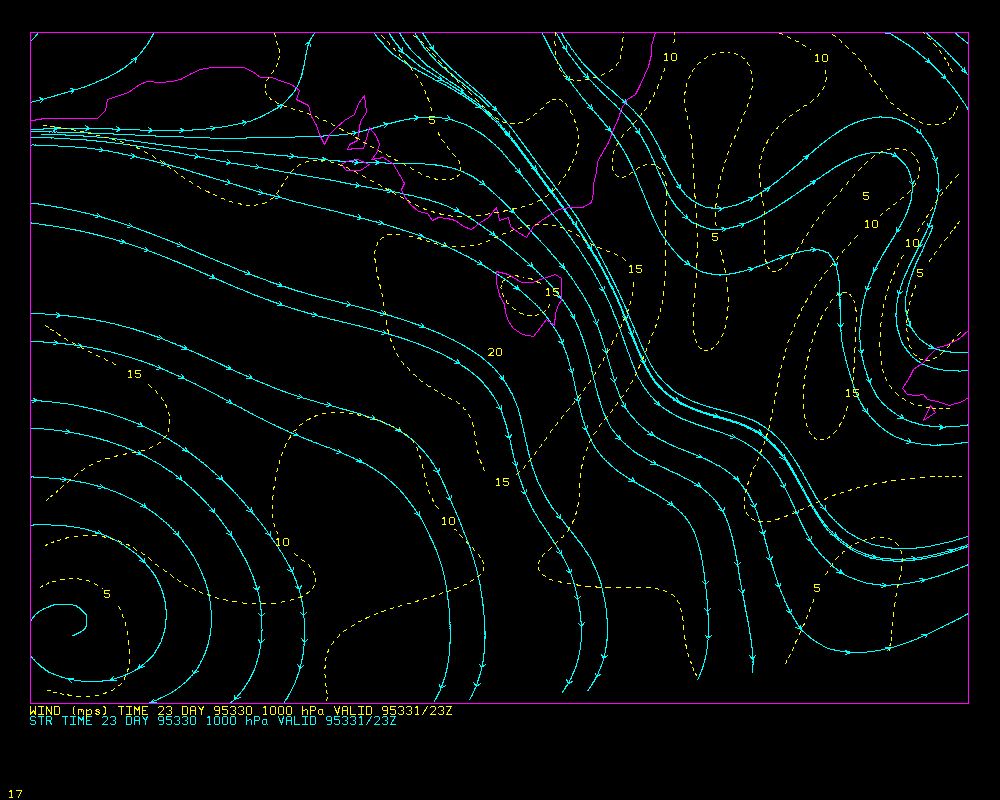
Surface Wind 24-h forecast is here
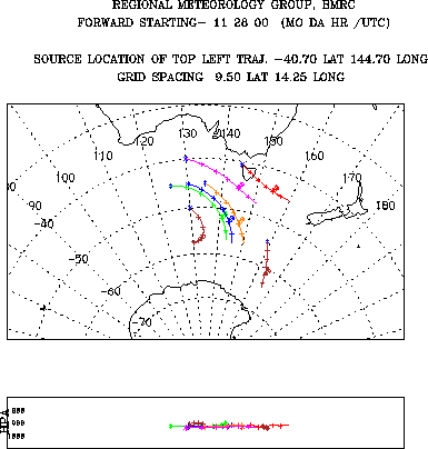
BMRC Hysplit trajectories are here
GASP trajectory analysis is here
SYNOPTIC AND PROGNOSTIC OVERVIEW.
ISSUED : 05Z Monday 27/11/95 VALID TILL : 12Z Tuesday 28/11/95
SYNOPTIC SITUATION AT : 00z 27/11/95 A ridge of high pressure extends from a 1020hPa high at 28S163E southward over Macquarie Island and is moving east at 10/15knots. A cold front on the west coast of Tasmania is expected to clear to the east overnight. A 988hPa low at 42S122E and associated cold front 37S120E/40S123E/43S122E is moving east at 40knots and expected on the west coast of Tasmania around 0000UTC - 0200UTC.
PROGNOSES : 0-24 HOURS : Both the GASP and US models are maintaining a strong low to the distant southwest of Tasmania with an embedded cold front approaching the state from the west and maintaining a strong northwesterly wind over Tasmania. However, the EC model is winding up an intense low 500nm to the southwest of Tasmania which may lead to the delay of the cold front expected to reach Tasmania around 0000UTC on the 28/11/95.
24-48 HOURS : Each of the models (US, ECMWF and GASP) differ in the movement of the long wave trough currently south of WA, however both the GASP and US models have the cold front clearing the east coast of Tasmania by 1200UTC on the 28/11/95. The EC model appears to have washed the front out and rapidly advected the low pressure system to the southeast leaving Tasmania in a strong (25-35knot) northwest stream rather than in a 15/25knot west to northwest stream.
72-96 HOURS: In the longer term all three models are maintaining a long wave trough just upstream from Tasmania with a fresh to strong west/northwest stream with embedded cold fronts.
DAILY FORECASTS.
ISSUED : 0530Z 27/11/95 VALID FOR TONIGHT AND TUESDAY 28/11/95.
CAPE GRIM : WEATHER : Periods of rain developing during the morning tending to showers during the afternoon with the passage of a cold front. WIND : A 10/15knot west to northwest wind shifting northwesterly during the morning and strengthening 20/30knots ahead of the cold front. Wind backing west/northwesterly 25/35knots west of front.
MACQUARIE ISLAND : WEATHER : Fine and partly cloudy at first although cloud increasing during the day with the chance of some drizzle by evening. WIND : A 10/15knot westerly wind shifting northwesterly and gradually freshening 20/30knots by evening.
R/V DISCOVERER : WEATHER : Periods of rain developing during the morning tending to showers during the afternoon with the passage of a cold front. WIND : A 10/15knot west to northwest wind shifting northwesterly during the morning and strengthening 20/30knots ahead of the cold front. Wind backing west/northwesterly 25/35knots west of front. A 1 to 2 metre sea rising 3 to 4 metres with the passage of the front. A 2 to 3 metre swell.
R/V SOUTHERN SURVEYOR : WEATHER : Remaining cloudy with occasional showers although increasing to rain during the day with the approach of a cold front. WIND : A 20/30knot north/northwest wind strengthening 30/40knots during the day. 2 to 3 metre seas rising 4 to 5 metres on a 3 to 4 metre swell.
REVIEW OF PREVIOUS DAYS FORECASTS: Forecasts appeared to be good although the ridge that moved over Macquarie Island was stronger with correspondingly better than forecast conditions. The wind forecast was very good.
Reporter: Phil Durkee
The current weather conditions present us with rapidly moving small storms that traverse the experiment region on about a 24 - 36 hour cycle. Finding measurement opportunities therefore require careful timing of these systems.
The conditions on 28 November will put Tasmania between fronts with a developing storm approaching from the west. Since the storm was just in its developing stages at the discussion time, a precise prediction of its location during operations scheduled for tomorrow was impossible. The clear air to the SE of Tasmania encountered during the intercomparison with Macquarie Island will move well out of range to the east before tomorrow.
The primary mission planned for tomorrow is designed to investigate the spatial distribution of the elevated layers of ultra-fine particles discovered during flight 14. The mission will be primarily flown in the cold-air cumulus field behind the front that is expected to approach Tasmania from the west. Departure time for tomorrow's flight will be 1000 LT with a possible delay due to uncertainty about the frontal position.
The plan calls for three sets of two-dimensional surveys of the vertical structure of aerosol layers with each set at different positions relative to the front. It is hypothesized that the vertical extent of the cumulus clouds controls the transport of gaseous precursors to ultra-fine particle production. Therefore, the concentration of particles should be greater in layers above higher cumulus tops. The surveys will be oriented over cumulus of differing cloud height to test this hypothesis.
The surveys will begin with a high altitude (20k ft) approached followed by a slow descent to within 100ft of the surface. The height of elevated layers will be identified during the desent. A 20 minute boundary layer leg will be flown below cloud base but above sea salt contamination. A slow ascent will follow that will try to determine the height of the layers roughly 100nm from the first descent. If the layers appear again in the ascent, an attempt will be made to fly a long leg along the layer. Alternating 5-7 minute legs in, above and below the layer. If a second layer was detected another long layer-leg may be flown. The total duration of the survey will be 1.5-2 hours depending on whether a second layer-leg is flown.
Alternate patterns may be flown if elevated layers are not found. One possibility is flying in clear air behind the front if the cold pool of air lags significantly.
In the coming days, we will continue to look for clean, cloud-free air for a sunrise photo-chemistry flight.