|
|
|
|
![]()
 Data Archive: OWLETS 2018 Data Archive: OWLETS 2018 
Relevant Data / Links |
|
Quicklook Reports
View / Upload Images & Data:
Lidar, UAV, Ground, Mobile, etc.
|
File Sharing:  Telecons, Meetings, Presentations, etc.
|
 NOAA's WRF HYSPLIT Meteorological Files
(ftp://ftp.arl.noaa.gov/pub/archives/owlets2/)
NOAA's National Weather Service Air Quality Forecast Guidance
|
|
2nd Annual OWLETS / 6th Annual TOLNet
Science Team Meetings, May 06-08, 2019
NCWCP, College Park, MD
|
ICARTT Data Format Document
|
|

|
| Project Description: |
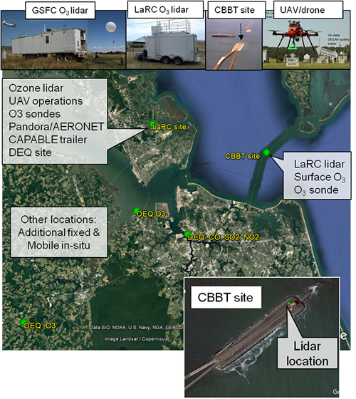
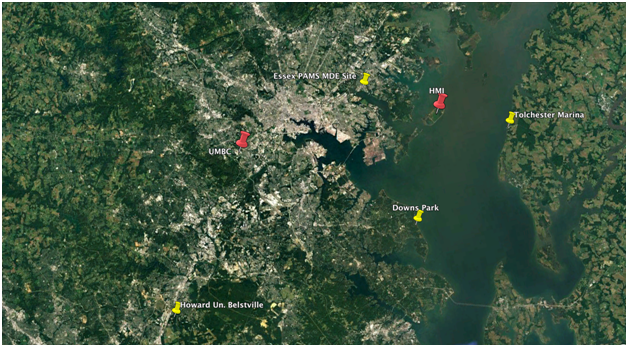
OWLETS-2 is a follow-on study to better understand the behavior of ozone and related trace gases across the water land transition zone in the upper portion of the Chesapeake Bay. At coastal boundaries, significant water-land gradients can occur due to difference in surface deposition, boundary layer height, and cloud coverage from water to land. Prior studies have examined the Chesapeake airshed with respect to ozone, but many questions remain due to the lack of over water measurements and incomplete information of the trace gas vertical distribution. OWLETS-2 will use a unique combination of measurements during summer 2018 (June 6 to July 6) to more fully characterize the behavior of ozone in the Baltimore region. This will include two ozone lidar systems, multiple wind and aerosol lidars, ozonsondes, UAVs, research aircraft, and a host of in-situ measurements at various locations. Two key super-sites, will be located at UMBC and Hart-Miller island, to obtain measurements simultaneously over land and water.
|
|
| Science objectives: |
OWLETS-2 aims to characterize pollutant formation and transport directly within the coastal transition region in the upper Chesapeake Bay with high resolution (space, time, vertical) observational dataset. Specific questions this study aims to answer are:
-
What is the spatial and vertical extent of the ozone (and ozone precursors) in and around the Chesapeake Bay? Synchronous lidar, balloon-borne, and surface observations of wind and ozone at HMI and UMBC will directly reveal vertical and spatial extent of ozone features.
-
What are the mechanisms (low boundary layer, chemistry, weather) that produce high ozone over the Chesapeake Bay and lead to high ozone at locations on land near the Chesapeake Bay? The synergy of lidar, balloon-borne, and surface measurements at HMI and UMBC will directly reveal differences in controlling factors related to air quality episodes such as: boundary layer heights and chemical composition.
-
How much of the ozone (ozone precursors) is a result of local sources (EGUs, mobile, ship, boat, etc) and/or pollutant transport (westerly, nocturnal low level jet) into Maryland? In commons flow patterns, observations at HMI and UMBC provide a detailed characterization of both upwind and downwind chemical composition that can directly quantify pollution transport entering the Baltimore region as compared to locally produced pollution.
-
Why do the photochemical models appear to over-predict ozone concentrations in and around the Chesapeake Bay? Lidar, balloon-borne and surface observations at HMI are direct aimed at better understanding photochemical models by providing boundary layer height, chemical composition, and flow pattern differences between land and water.
-
What source groups and in what locations do policy makers need to focus on to reduce ozone over the Chesapeake Bay? The results of this study will offer recommendations to policy makers and other interested agencies on how to more optimally place sensors in order to better reduce ozone over the Chesapeake Bay.
-
How can measurements be better utilized (in conjunction with chemical transport models) to connect ground level pollutants to satellites in the upcoming framework of the NASA TEMPO instrument? Repeated high-resolution measurements under a variety of atmospheric conditions will help provide the statistics needed to test and optimize satellite retrievals and comparisons.
|
| Science Team Information: |
- John Sullivan PI, NASA Goddard Space Flight Center
- Joel Dreessen Co-PI, Maryland Department of the Environment
- Ruben Delgado, Co-PI, University of Maryland Baltimore County
- Tim Berkoff, Co-PI, NASA Langley Research Center
|
|
Data Archive: OWLETS 2017
Relevant Data / Links |
Quicklook Reports
View / Upload Images & Data:
Lidar, UAV, Ground, Mobile, etc.
|
File Sharing: Telecons, Meetings, Presentations, etc.
|
|
NOAA's National Weather Service Air Quality Forecast Guidance |
|
2nd Annual OWLETS / 6th Annual TOLNet
Science Team Meetings, May 06-08, 2019
NCWCP, College Park, MD
|
ICARTT Data Format Document
|
|

|
| Motivation/Background |
-
Significant land-water gradients in coastal regions can occur due to differences in surface deposition, boundary layer height, and cloud coverage, example to right is an EPA/CMAQ surface ozone example case
-
Studies have examined the Chesapeake air-shed with respect to ozone including: Martins et al. 2012 (Hampton Roads region), Goldberg et al. 2014, Loughner et al. 2014, Stauffer et al. 2015 (Baltimore-DC region)
- O3 measurements over water are scarce
-
NASA Looking Forward: Vertical, horizontal, and temporal (4-D) measurements are needed to describe complex scenes to improve forecast models and air quality satellite retrievals
- TEMPO/GEOCAPE
-
Key goal: provide user community high resolution vertical O3 profiles simultaneously over the land and water during various air quality events
- Daytime, nighttime, sunset/sunrise, poor AQ days as well as clean
more » |
| |
|
» Article: NASA Chesapeake Bay Study To Help Improve Air-Quality Forecasts
![]()
|
|
|
|