Mission Plan:
Primary Mission : Langrangian continuation Alternate Mission: N/A Future Mission(s): Continuation of up to two more flights on the Lagrangian mission, possibly extending through 1130 UTC Sunday 3 December ( 2230 LDT, 3 Dec).Aircraft Operations
Take-off Time: Flight #20. 0230 LDT, Sunday 3 Dec (1530 UTC, 2 Dec) Flight #21. 1330 LDT, Sunday 3 Dec (0230 UTC, 3 Dec) Pre-flight Weather Briefing Time: Flight #20, 0030 LDT, Sunday 3 Dec (1330 UTC, 2 Dec) Flight #21, 1130 LDT, Sunday 3 Dec (0030 UTC, 3 Dec) Updates: Lagrangian decision update will be made at approximately 2300 LDT (1200 UTC, 2 Dec), following the debriefing of Flight #19. Airborne Mission Scientist: Flight #20, Wang Flight #21, Huebert Mission Scientist: Flight #20, Huebert Flight #21, DurkeeShip Operations
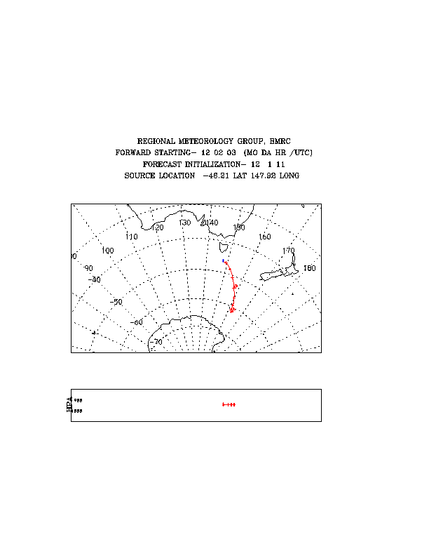
Discoverer: Discoverer located at approx 46S 143E this evening heading eastbound along the Lagrangian track. They will continue along this track until reaching approx. 148E. ISS soundings are taken every 3 hours in support of the Lagrangian mission. These will continue through 1200UTC 02/12. See catalog reference below for detailed instrument status. Discoverer Lead Scientist: Tim Bates Southern Surveyor: Southern Surveyor position at 0600 UTC 02/12 is approximately 46 30'S 147E. When they reach 46 30'S, they will turn downwind along the Lagrangian track and continue sampling. An attempt will be made to have an aircraft flyover of the Southern Surveyor during the third aircraft sequence mission tomorrow. Soundings are scheduled every 6 hours, if possible. See catalog reference below for detailed instrument status. Southern Surveyor Lead Scientist: Bronte Tilbrook
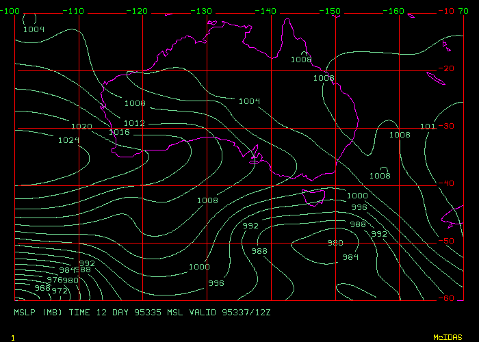
48 hour MSL P Prognosis is here
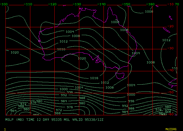
72 hour MSL P Prognosis is here
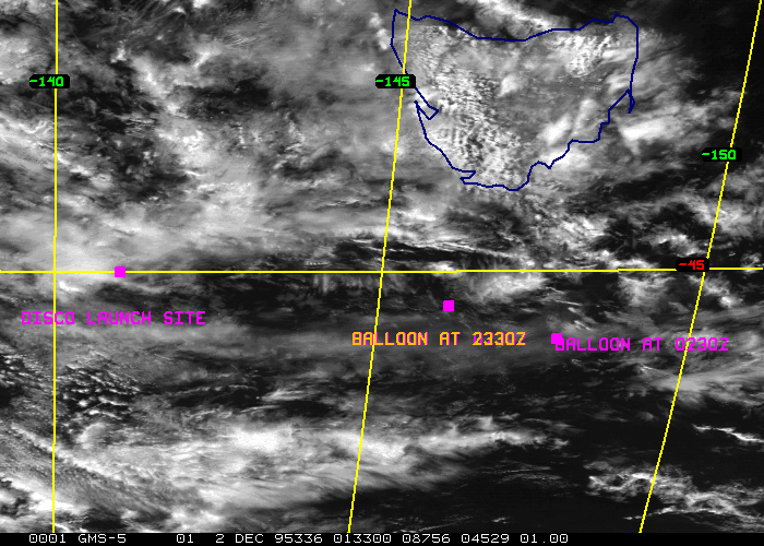
Latest Visible Sat Picture is here
Surface Wind 24-h forecast is here
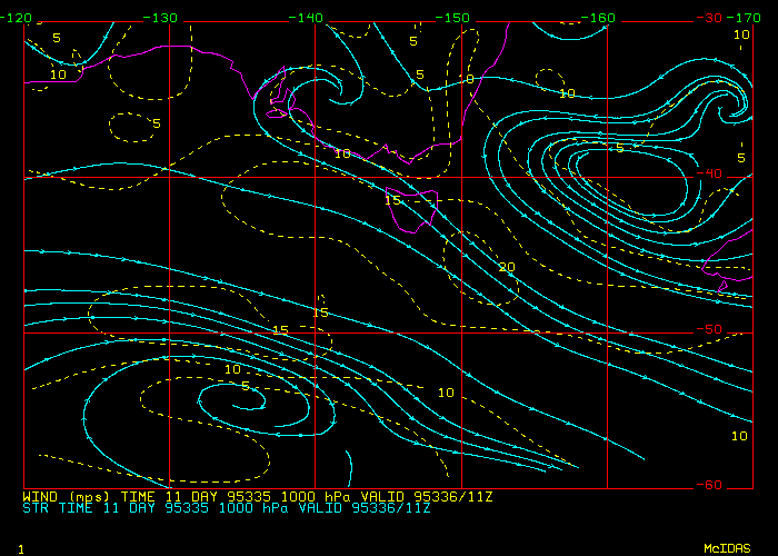
BMRC Hysplit trajectories are here
GASP trajectory analysis is here
Synoptic Situation at 00Z Saturday 2/12/95:
Weak cold front extends from the south coast of Tasmania to 50S 159E into a 990 hPa low near 53S 152E. Front is moving E at 30 knots.
A second, stronger front located near 40S 117E/45S 133E/50S 138E into a 978 hPa low near 53S 130E. Front moving SE at 40 knots forecast to be near 43S 148E/50S 144E/into a 980 hPa low near 54S 132E at 12z tonight and weakening quickly. Front will be embedded in a strong northwesterly airstream and is likely to dissipate east of 150E early tomorrow morning.
Another cold front is forecast to develop near 130E tonight and move eastwards at 25/30 knots to be near 33S 130E/43S 140E/into a 980 hPa low near 52S 138E at 00z tomorrow and be near 40S 150E/45S 152E/into a 980 hPa low near 50S 150E at 12z tomorrow night. The strong, cold west to southwest stream in the wake of this front is expected to spawn new fronts and lows in the area around 50S 140E on Sunday night, which will move through the Discoverer/Southern Surveyor/Cape Grim region during Monday.
Prognoses:
0-24 hours: Some discrepancies have become evident betwen the models in the way they are handling the cold front and low complex southwest of Tasmania tomorrow night. The EC is developing a low due S of Tas by 12z tomorrow night, whereas the other models have got the low further south. The latest satpics would indicate development taking place around 50S, so the EC is preferred at this stage. The progs are consistent in developing a new front near the line 45S 130E/50S 140E by 12z tomorrow night, and following this will be a burst of strong, cold south to southwest winds.
24-72 hours: The EC and the US progs look very similar for the following 48 hours, pushing the front through Tas and into the Tasman on Monday, with a secondary development in the cold air moving through a line Hobart/50S 155E on Monday night. A high following the front is forecast to move in south of the Great Australian Bight on Monday night and extend a ridge SE towards 50S 145E (across the Disco's area?), with the ridge pushing eastwards on Tuesday across Tasmania.
FORECASTS for tonight and Sunday:
Cape Grim: Weather: A few showers, increasing tomorrow afternoon. Becoming colder tomorrow evening following the change. Wind: West to northwest winds 15/25 knots tending more northerly tomorrow and increasing to 20 to 30 knots during the day ahead of a late west to southwest change of similar strength.
Macquarie Island: Weather: A few showers increasing for a period tomorrow morning as the next front moves through. Light showers or drizzle following the front with some low cloud and/or fog developing late in the day. Wind: North to northwest winds 15/25 knots tending northerly tomorrow and increasing to 20/30 knots during the afternoon.
R/V Discoverer Weather: Showers developing shortly (if they haven't already) then easing following the front, forecast tomove through your area about 10/12Z, assuming you are still tracking E from your earlier position at 15/18 kts. Adjust the timing accordingly. Wind: Northwest winds 25/30 knots, possibly reaching 35 knots ahead of the front this evening with stronger squalls likely with the change itself. Winds backing westerly at 25/30 knots with the front but returning to the northwest tomorrow morning and increasing to 25/35 knots ahead of another 20/30 knot west to southwest change in the afternoon. A southwest to southerly change developing tomorrow night. Seas rising to 3 metres tonight and possibly 4 metres tomorrow just ahead of the front. Westerly swell increasing to 4 metres.
R/V Southern Surveyor Weather: Showers developing this evening then easing following the front, forecast tomove through your area about 11/13Z, assuming you are still tracking NE from your earlier position. Adjust the timing accordingly. Wind: Northwest winds 25/30 knots, possibly reaching 35 knots ahead of the front this evening with stronger squalls likely with the change itself. Winds backing westerly at 25/30 knots with the front but returning to the northwest tomorrow morning and increasing to 25/35 knots ahead of another west to southwest change of similar strength late tomorrow. A southwest to southerly change developing tomorrow night or early Monday morning.. Seas rising to 3 metres tonight and possibly 4 metres tomorrow just ahead of the front. Westerly swell increasing to 4 metres.
REVIEW OF PREVIOUS DAY's FORECASTS:
Early this morning, low and high cloud moved over the area in which the Lagrangian experiment is being conducted, however most of the low cloud appears to have cleared this afternoon, judging by the satpics. Wind conditions have been close to those forecast, although the trajectories have tended to move the balloon too far south. This strong southeastwards motion is because the progs failed to pick the development of the low near 55S 150E today, which has kept the winds more westerly rather than northwesterly. On the main platforms, weather has been much as forecast although the front moved through Macquarie slightly earlier than forecast. Winds have been very close to those forecast, albeit at the lighter end of the forecast range at Cape Grim and the Discoverer. Seas and swells have been a little less than those expected for the Southern Surveyor, for which, I'm sure, they will be greatful.
Reporter: Barry Huebert
The Lagrangian experiment discussed in yesterday's (1 Dec) Daily Summary has begun on schedule. See yesterday's Scientific Issues and Discussionfor details.
Our continuing Lagrangian mission schedule is as follows:

Saturday:

0030   Flight #18 Debrief

0100 Weather brief, assuming Air NZ flight has cleared from terminal

0130 C-130 T/O Hobart, Flight #19

1030 C-130 Land Hobart

Sunday:

1330 Weather brief

1530 C-130 T/O Hobart, Flight #20

0030 C-130 Land Hobart
     Weather brief

0230 C-130 T/O Hobart, Flight #21
     (tenuous, but we want to maintain the option)

1130 C-130 Land Hobart

Again, conditions which would terminate the Lagrangian experiment include:

     1. Precip or convection ruining the integrity of the BL
     2. Less than 2 1/2 hours on station due to long ferries
     3. Not having a balloon to follow

If we acquire both balloons, we would use trajectories and satellite
information (a high resolution image is due in at 1545 Saturday morning,
just after takeoff) to select the clearer of the two. The last launched
might be most desirable in terms of our staying with it longer, but that
air might also degrade sooner due to its proximity to the following front.
If no balloon is acquired, we will seek the best clear patch of clean air
(there should be plenty tomorrow morning) and fly a sunrise experiment in
it.